Managing Flood Risk
WAVE Project Modelling and Mapping Flood Risk
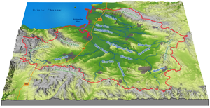 Click on the map to explore the flooding of different magnitudes and the effects of climate change across the WAVE
study area
As part of the Somerset WAVE project JBA Consulting have undertaken some new broad scale hydraulic modelling of flood risk across the study area, covering:
- Fluvial flooding
- Tidal flooding
- Surface water flooding
Hydraulic models are computer simulation tools that are used to represent the real physical characteristics (both natural and man-made) of a catchment or coastal area and the hydrological elements (namely, rainfall, surface runoff, river flow and tidal mechanisms) and processes acting on them which drive the fundamental causes and consequences of any flooding that take place. The models that are built, tested and validated using a range of datasets from the study area can then be used to explore a whole suite of flood magnitudes and other scenarios in order to map the extent and depth of any flooding that is generated.
The modelling of flood extents and flood depths for particular flood event magnitudes, including possible climate change effects, is a fundamental part of the Environment Agency’s strategic flood risk management planning process which includes the production of Shoreline Management Plans (SMPs) and Catchment Flood Management Plans (CFMPs). Click here to find out more about strategic flood risk management planning.
Existing fluvial and tidal flood models of the Somerset WAVE area have been revised, updated and adapted to generate new flood extent and flood depth maps for a range of flood magnitudes, both for the present day (2010) and for the future year 2060 taking account of the projected climate change impacts. The scenarios modelled included both the defended (with the existing flood defences in place and maintained to the present day levels), and undefended (with the existing flood defences removed) situations.
The new modelling undertaken for the surface water flood mapping was chosen to represent a particular catchment condition, namely an intense rainstorm event following a long dry period (including the summer months). At this time the surface condition across the whole rural area would be expected to be more impermeable. As such this condition would act to force much of the incident rainfall to flow laterally along natural surface flow pathways towards depressions and eventually finding its way into the existing drainage network.